From throne to trowel, this poetic reflection traces the life of Puyi—from imperial captivity to peaceful obscurity—revealing how China’s last emperor found dignity not in power, but in planting a single flower.
The Last Gate
It did not feel like exile. It felt like air.
Crisper than I had expected, colder than I had ever known. Outside the red walls, the wind behaved differently — it had no memory, no protocol, no need to announce itself. In the Forbidden City, even the wind bowed.
My shoes were wrong for this. Soft soles meant for silk carpets, not flagstones wet with Beijing’s early winter. I was dressed formally — not for ceremony, but out of habit. When you are Emperor from the age of two, dressing down feels like treason.
A general, or perhaps a policeman — it’s difficult to say who wore what in that period — motioned silently to the cart. A rickshaw. Not even a carriage. I didn’t protest. I stepped in. The wheels squeaked. Behind me, the vermilion gate closed. Not loudly. Just… finally.
I looked once over my shoulder, half-expecting some retainer to appear, to whisper “There’s been a mistake, Your Majesty.”
But no one came.
The gate, with its nine brass studs across each panel, was just a gate now.
A Guest with No Kingdom
The Japanese legation compound stood in the old Legation Quarter — a leftover from another era of humiliation, where Western powers and Japan had carved out slices of my capital and flown foreign flags above our soil. Now I arrived not as emperor, but as a guest without a kingdom. My welcome was polite, mechanical. They called me “Your Majesty” with the tone one might use to address a child who still insists on being called “Captain” weeks after losing his toy boat.
They offered me a modest suite — carved screens, lacquered panels, a writing desk too ornate to be useful. I tried to write once. A diary entry. I tore it up. It was all adjectives and no feeling.
Reginald Johnston visited once or twice, his eyes grey with something like pity. He had been my tutor, my friend, my bridge to the modern world. He had tried, in vain, to prepare me for life outside the walls. Now he stood awkwardly in the threshold, hat in hand, watching as the world he once translated for me now consumed me whole.
“You’re being treated decently?” he asked.
“Yes,” I said. “As a museum piece is treated.”
He frowned. “Don’t let them use you, Puyi.”
I laughed then — a thin, sharp sound. “Is there another option?”
The days passed slowly. I was neither free nor captive. Not a prisoner, but not allowed to leave without permission. The staff brought meals. Courteous, distant. The Japanese advisors came often. Polite at first, then more confident. They spoke of destiny, of restoration, of Manchuria.
“You were born to rule,” one said, eyes gleaming behind round spectacles. “And Manchukuo needs a ruler.”
I asked what “Manchukuo” was. He produced a map. A puppet outline of a country that did not yet exist. I was to be its emperor. A new dynasty, they said. Modern, orderly. Japanese-guided, of course — but mine in name. They called it a sacred duty to the people of Asia.
I stared at the map. I saw no throne. Just train lines, coal fields, military zones, factories.
But I nodded.
I told myself this was my chance to make something of the past. A bridge between eras. That I would rule wisely. That I would not be a puppet.
But deep inside, I knew the truth.
They were offering me a costume. And I, desperate for the applause of history, was too vain to refuse.
Nights were the worst. In the Forbidden City, I had often heard nothing but the rustle of robes and the distant call of drums. Here, the city was alive. Trams screeched. Men shouted. Radios buzzed with unfamiliar music. Beijing no longer whispered. It shouted over me.
I once ventured to the edge of the compound, where I could see the street. A child ran past, laughing, chasing a paper kite. He did not bow. Did not look. He had no idea who I was.
And for the first time in my life, I felt something close to envy.
Not of his freedom — I did not yet understand that.
But of his irrelevance.
Manchukuo: The Emperor’s Mask
They met me at the station in Changchun with banners and artificial smiles. It was 1932. Snow dusted the rails, clean and bright, like the surface of a lie. They had renamed the city Xinjing — “New Capital.” I was not fooled by the name. New cities are not built from steel and slogans, but from trust and soil. This had neither.
My arrival was staged like a play. Soldiers lined the route. Schoolchildren waved flags none of them understood. The Japanese officials smiled with the smug satisfaction of stage managers watching their puppet enter stage left on cue.
I was led to my new residence — not a palace, but a mansion. Square, sterile, built in Japanese modernist style. It had everything except history. No ghosts in the beams, no echoes in the stone. Just furniture polished to the point of absurdity, and paper walls that let in every sound except truth.
They called me “Emperor of Manchukuo.” But I was no longer even the shadow of an emperor. I was a figurehead for a nation that existed on maps printed in Tokyo and nowhere else. The cabinet ministers were Japanese. The military was Japanese. Even the food on my table bore the flavours of Kyoto, not Beijing.
I once asked to appoint my own minister of justice. The request was met with a pause, followed by a soft “We will consider it.” I never received a reply.
And yet — part of me welcomed the theatre.
I wore the robes. I stood on balconies. I signed decrees written in a language I no longer trusted. I delivered speeches full of rhetoric about harmony, progress, and Asian brotherhood, knowing full well the brother wore a sword.
The throne was a polished chair. The sceptre was a fountain pen. The empire was a lie.
But I smiled. I told myself lies too. That I was keeping China alive, even in exile. That I would regain influence. That I could guide the future from behind the curtain, like the old regents in the Hall of Supreme Harmony.
But when I looked at my reflection in the lacquered black of my desk, I saw no Son of Heaven. I saw a young man rehearsing authority. A borrowed emperor, seated atop a ventriloquist’s stand.
My court was a museum. We paraded rituals whose meanings had vanished. There were still kowtows, still officials in Qing dress — but their eyes were empty. One courtier told me of his new Japanese watch, then bowed three times with perfect formality. Another drank heavily and muttered that “emperors are for calendars.”
Once, during a storm, the power failed. The lights went out. No one moved. I sat alone in the throne room, lit by a single candle someone had placed near the dais. The wind howled outside. I imagined the Japanese standing just beyond the walls, watching, smirking, waiting for me to panic.
I did not. I sat there, silently, until morning.
And that was when I knew.
I was no longer even pretending to rule. I was pretending to be me.
The Collapse
The empire ended not with gunfire, but with silence.
It was August 1945. The Japanese had surrendered. Hiroshima had been flattened. Nagasaki followed. I heard the news in fragments — a nervous official with cracked glasses whispered of “unconditional surrender,” his voice trembling more from disbelief than fear.
In Manchukuo, the Japanese commanders vanished almost overnight. Uniforms were stripped, flags burned, papers dumped into fireplaces that hadn’t been lit in years. The palace, once a hive of surveillance and staged ceremony, became eerily quiet. A few aides remained — confused, loyal, or simply too late to flee.
I was told to flee. “Your Majesty, we must get you to safety.”
Safety. An interesting word for a man who had never known what danger truly was.
They put me on a plane — a Japanese military transport, rusty and unreliable. It lifted from a makeshift runway with smoke on the horizon and my stomach full of dread. I was still carrying the imperial seal, tucked in a velvet pouch beneath my coat, as if I could stamp my way out of oblivion.
We didn’t get far.
The Soviets found us in Mukden. I had hoped they would treat me as a dignitary. Perhaps allow me exile. Perhaps hand me gently to the Americans, who, I told myself, might appreciate the novelty of an emperor.
Instead, I was loaded into a truck, then a train, then a grey building where my name had no value.
The Russian guards did not beat me. They did not speak to me. They watched. Like I was something in a jar.
I was held in a place called Khabarovsk — a military compound of concrete and questions. The food was bland but sufficient. I was not mistreated. Just… neutralised. I spent my days staring at frost-rimmed windows and wondering if they would ever call my name again.
They didn’t.
Weeks became months. The winter froze even my thoughts. I began to doubt I had ever been emperor. The court, the robes, the rituals — they felt like scenes from a play I had performed in too long ago to remember. I dreamt of the Forbidden City, but the colours were fading. The yellow roofs, the incense, the calligraphy — they drifted in my memory like petals on water.
One night I asked the guard for a pen. He didn’t understand. I mimed writing. He shook his head.
I never tried again.
Eventually, they handed me over.
It was 1950 when the Soviets, tiring of their Chinese trophy, gave me back. Not to restoration, as I had once fantasised, but to the People’s Republic — a country reborn in slogans and cement.
I was told I would be “re-educated.”
At first, I laughed. Quietly, but bitterly. How do you re-educate someone who had never been properly educated in the first place?
But I was sent to Fushun War Criminals Management Centre all the same.
There were no guards with whips. No chains. Just beds, grey walls, and a new kind of theatre — one where the audience and performers were the same. Each morning we woke, saluted Mao’s portrait, and recited lessons. We confessed. We critiqued one another. We debated ideology with the earnestness of drowning men describing the sun.
And slowly, something happened.
I stopped lying. At first in small ways — admitting fear, embarrassment, vanity. Then in larger ways — admitting complicity, cowardice, blindness. I read Marx not because I believed, but because I needed something to fill the hollow.
I swept floors. I cleaned toilets. I wrote pages of reflection, trying to understand how I had become so empty, so used to being used.
I began to believe the re-education was working.
Not because it gave me truth.
Confession and Re-education
They gave me a grey uniform and a number.
I was no longer “Your Majesty,” no longer even “Puyi.” Just inmate 981. At Fushun War Criminals Management Centre, names were an indulgence of the past. We had categories now: traitor, collaborator, counter-revolutionary. I was all three. I wore it like a second skin, stitched by the choices I had convinced myself were survival.
My first task was to sweep the corridor. It took me two hours — not because it was long, but because I had never held a broom. The bristles caught on the uneven concrete, and the handle gave splinters. My palms bled, a quiet rebellion from hands that had once signed edicts on silk scrolls.
I thought the guards would jeer, or mock. They didn’t. They watched. Always watching. Like gardeners waiting to see if a buried seed would sprout or rot.
The real punishment was not physical. It was dialogue. Every day, group sessions. Eight men in a circle, stools arranged like a tribunal. We recited the “Three Critiques”: critique of the self, of others, of the imperialist past.
At first, I spoke in abstractions.
“I was misled by my advisors.”
“I was unaware of the suffering.”
“I was a child in the hands of stronger powers.”
But they weren’t interested in excuses. They wanted blood. They wanted my soul, or the admission that I had never had one to begin with.
So I began to say it.
“I betrayed my country.”
“I aided the invaders.”
“I let men die for the sake of my throne, which was not a throne at all, but a prop.”
The first time I said those words, something cracked. Not loudly. Not like a bowl shattering. More like the subtle sound of paper tearing down the spine.
I cried that night, in the dark. Not out of sorrow. Not even guilt. But confusion. I no longer knew what was true. Was I sorry because I understood? Or because they wanted me to be?
Months passed. Then years.
I kept confessing. First out of fear. Then habit. Then, unexpectedly, relief.
The act of confession became something like prayer. A form of worship — not to Mao, not to Marx — but to reality. To clarity. I began to recognise patterns in myself: the vanity of my boyhood, the selfish hunger for status, the constant search for someone to blame.
I once watched a fellow inmate — a former general — break down after admitting he had ordered executions for personal revenge. He sobbed like a child, then looked at me and said, “I thought I was serving order. I was just cleaning up after my own pride.”
I nodded. I understood. The line between order and vanity had blurred for both of us long ago.
One afternoon, I was brought before a tribunal. Not for sentencing, but for evaluation.
A man in a brown tunic — expressionless, his hair thinning — asked me, “What are you now?”
I replied, “I am a Chinese citizen.”
He raised an eyebrow. “Not a monarch? Not a victim?”
I looked at the floor.
“I am… a man who once thought he was above other men. Now I am simply one of them.”
He nodded. Wrote something. The meeting ended. Three months later, they told me I would be released.
I left Fushun with no fanfare. I had entered a prisoner. I exited a man with a folded shirt, a toothbrush, and a modest pension from the state. The gate did not feel like freedom. It felt like air again — familiar, cold, and indifferent.
I looked at my hands. They were rough now — scarred from work, not warfare. Fingers once manicured by eunuchs now calloused by years of scrubbing floors and cleaning latrines. And yet, for the first time in my life, they felt like they belonged to me. Not instruments of ceremony or symbols of inherited rule — just hands. Capable, honest, and mine. I had learned how to use them — not just to sweep or carry, but to live without illusion. That, above all, was what re-education had given me: not truth, but the slow, merciful removal of every lie I had once mistaken for purpose.
The Faces of Revolution
I returned to Beijing like a man waking from a long illness. The streets were unfamiliar. Not because they had changed — though they had — but because I now saw them without tinted glass. I was no longer carried, protected, or observed. I was simply… present.
The old palaces had been turned into museums or offices. The alleyways buzzed with bicycles and vendors. No one bowed. No one saluted. Most didn’t look at me at all.
That, more than anything, felt like freedom.
I lived in a small government dormitory, a concrete building the colour of boiled rice. I was given a ration card, a basic stipend, and instructions not to “interfere in political affairs.” I had no intention of doing so. The only affairs that concerned me now were water, soil, and light.
The job came through a Party liaison — gardening assistant at the Botanical Institute. I was to weed, water, and prune. A peony bed in the south courtyard became my first charge. I tended it as one might an old friend who had returned after many years — quietly, carefully, and with unspoken regret.
One crisp morning, as I knelt beside a row of sweet osmanthus, a voice behind me said, “Your Majesty, may I?”
I turned sharply.
An older man stood there, lean, stoop-shouldered, his face weathered like dry parchment. He wore the standard blue Mao tunic, but there was elegance in his stillness.
“I used to serve you,” he said, with a gentle smile. “You wouldn’t remember me. Few did.”
I stood slowly. “You’re mistaken. I don’t—”
“No, no,” he said, waving the air gently. “I didn’t expect you to. I polished brass hinges in the Hall of Mental Cultivation. Daily. For ten years. We saw each other most mornings — though I doubt you saw me.”
He bowed, not out of deference, but familiarity. A habit he hadn’t quite shaken.
I stared. “You’re right. I don’t remember. I’m sorry.”
He smiled again, more warmly this time. “There’s nothing to be sorry for. You were a prisoner. A gilded one, but still a prisoner. Every meal brought on a tray, every opinion chosen for you before you spoke. You saw what they wanted you to see.”
His clarity startled me. “I thought I was ruling.”
“You were being managed,” he said softly. “That’s not the same.”
We sat on a nearby bench, the garden blooming quietly around us. He introduced himself simply as Mr. Shen. No surname, no titles. Just a name carried through decades like an old coin in a deep pocket.
I asked about his life.
“Uneventful, mostly,” he said. “Which is a kind of blessing. We were poor. Still are, in truth. But I married. We had four children. One died. Three live. One teaches maths, one drives a coal truck, and one —” he paused, chuckled, “writes slogans for the Ministry of Culture. He’s very clever. I don’t understand half of what he says, but it sounds patriotic, so I nod.”
I laughed with him.
He turned his gaze to the gravel path. “I was almost beaten to death once.”
I blinked. “By whom?”
“Japanese soldiers. 1942. Caught me with food I wasn’t supposed to have. It was meant for a starving neighbour. I said nothing. Took the beating. They left me half-conscious in a shed near the railway.”
He scratched the side of his neck thoughtfully.
“One of the younger soldiers returned. A boy, really. Barely seventeen. He was shaken. Said he didn’t agree with what had happened. Asked if I needed water.”
“Did you take it?” I asked.
“No. I gave it to him. He had a wound on his arm. Nothing terrible, but infected. I cleaned it. Told him how to wrap it.”
“Why?” I said, surprised.
Mr. Shen tilted his head. “Because he was human. And I didn’t want to carry more hatred. It’s heavy.”
I said nothing. He continued.
“Three days later, that boy came back with forged documents and whispered a single name to me. A Korean merchant who smuggled people out through a checkpoint. My wife and I took the risk. We walked three nights and didn’t look back.”
He rubbed his knees. “Sometimes one life is saved by another. Without ever knowing it.”
We sat in silence for a while. The scent of damp earth and chrysanthemum drifted on the breeze. I turned to him.
“Do you think I can still be… of use?”
He looked at me calmly. “You already are. You’re here, aren’t you? You’re speaking truth. You’re planting things that will outlive you. What more do you want?”
I sighed. “To know I was more than just a mistake.”
Mr. Shen put a hand on my shoulder. “You weren’t a mistake. You were a boy placed in an impossible role. Now, you are a man choosing a quiet one. That is something.”
That night, in my room, I picked up my small journal. I wrote just one sentence:
“Today, I met someone who remembered me as I was — and forgave me as I am.”
Peonies and Dust
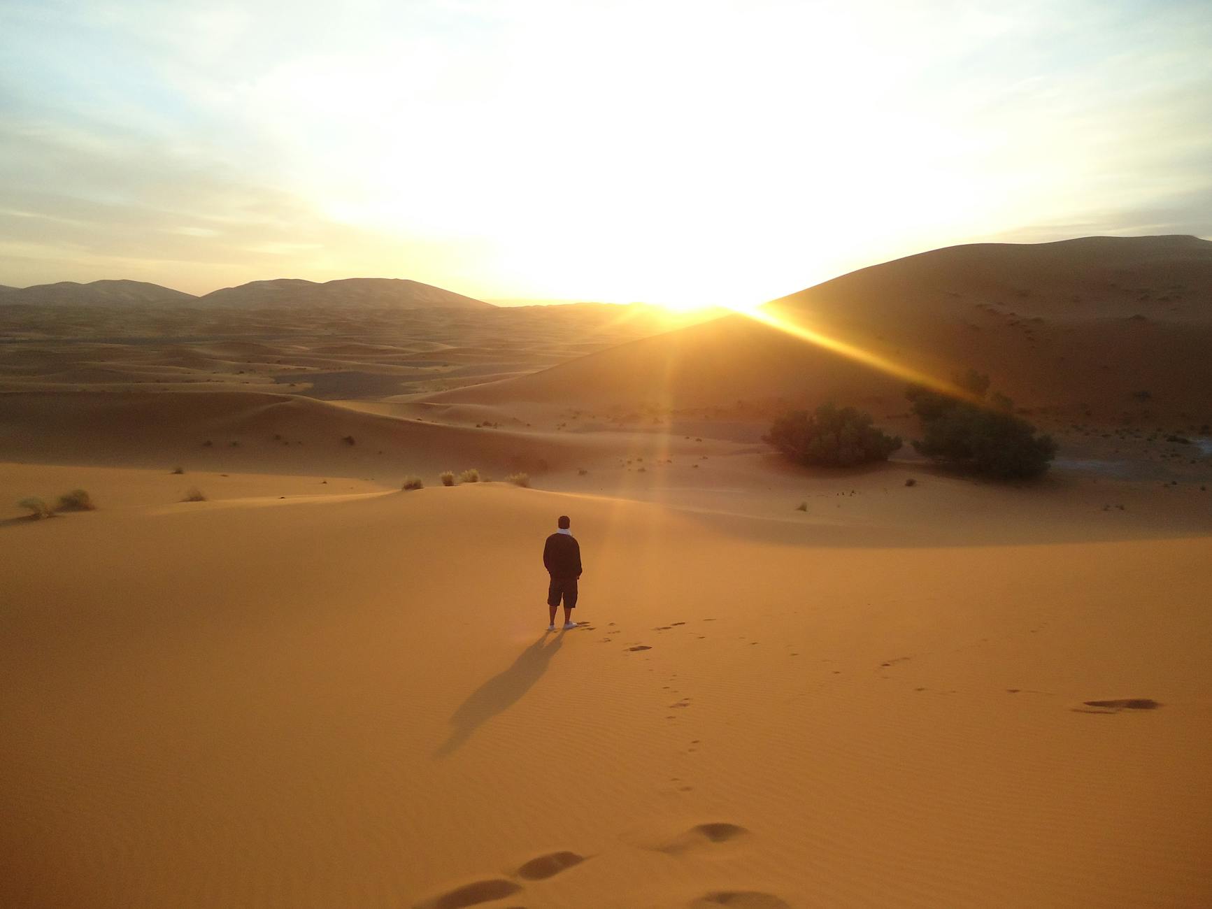
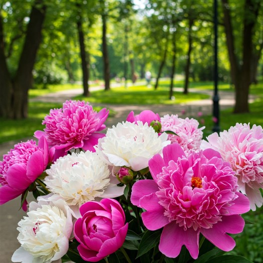
The peonies arrived in April, shy and swollen with promise.
They emerged slowly, with the kind of patience I had never been taught. First a green bud, tight and folded like a secret. Then a hint of blush, then pale pink petals that unfurled as though remembering something. I watched them each morning with the reverence once reserved for court ritual.
They were neither obedient nor indifferent — simply alive. They grew with no ceremony, no command. And they did not need me to bloom. My work was only to remove the stones, to guard against disease, to ensure water reached where it must. That, I had come to believe, was enough.
The old instincts still flickered now and then. When someone bowed a little too deeply, I stiffened. When I heard the word “Majesty” on the radio — even in reference to foreign royalty — my breath caught for half a second.
But those moments passed more quickly now.
I began to see people differently too.
A woman who worked the compost heap, hands stained brown to the wrists, taught me how to turn kitchen scraps into soil. A Party clerk, who used to draft propaganda posters, gave me a cutting from his grandfather’s orchid and said, “Even slogans need beauty.” The quiet girl from the herb garden read poetry aloud on Tuesdays, her voice trembling only when she recited from memory.
No one cared who I had been. Most had never heard of me. A few thought I had been an actor.
And in that anonymity, I found something extraordinary — not freedom exactly, but permission. To be.
I had never been allowed to be before. Not as a child-Emperor locked behind walls. Not as a puppet ruler blinking into cameras. Not even in Fushun, where I had to confess my soul in someone else’s language.
Now, I carried water. I turned soil. I spoke plainly.
One afternoon I caught myself scolding a boy — a volunteer who had crushed a patch of young chrysanthemum with his bicycle.
“You don’t understand,” I snapped. “That bed took two seasons to root properly!”
He looked terrified.
I stopped, realising how absurd I must have sounded. I exhaled slowly, crouched beside the damage, and showed him how to lift the roots gently, how to replant what could be saved. He listened, wide-eyed. I realised I was smiling.
Later, I wrote:
“Once, I ruled men who feared me. Now I teach boys to be gentle with roots. This is better.”
At dusk, when most had gone home, I often stayed behind. Not out of duty — I was no longer trying to impress anyone. But because the light in the garden was kind in the evening, slanting low and gold across the stone paths. Dust would rise in the air, catching the sun, and for a brief moment everything seemed suspended — like the final page of a story before the book is closed.
Sometimes I’d find Mr. Shen there, watching the light with the quiet satisfaction of a man who has earned nothing and regrets even less.
“You’ve changed,” he said one evening, handing me a flask of warm tea.
“Not sure that’s the word,” I said. “More like… unravelled.”
He nodded. “Then perhaps now, finally, you’re becoming someone.”
I often thought about legacy. Not the statues and names engraved in stone. That kind of legacy was too fragile, too prone to melting under a new flag. No, I had come to see legacy in a different way.
In the health of the soil.
In the bloom of a flower long after the hand that planted it has turned to dust.
In the young gardener who will one day step into my patch, dig with the same care, and never once wonder who planted the first root.
And that, I thought, was as it should be.
Visitors in the Garden
It began with a photograph.
Someone — perhaps a Party functionary, perhaps a former court hanger-on who had reinvented himself — had published a grainy image of me in a gardening cap, pruning shears in hand, beside a rosebush. The caption read:
“Former Emperor Puyi: Now a Model Citizen.”
It was meant as propaganda. Proof of the revolution’s success — look how even the last emperor tills soil beneath the watchful eye of the People’s Republic. But Beijing is a city of whispers, and whispers travel faster than any newspaper.
Within weeks, they started coming.
Not in crowds. Not with banners. Just one or two at a time. Middle-aged women with hesitant smiles. Men who lingered at the garden gate, pretending to read the plant names. Some approached quietly, with eyes full of history.
“Were you…?” they’d ask, almost embarrassed.
“Yes,” I would say, before they finished. “That was a long time ago.”
Sometimes they asked for my opinion on politics. I had none to give. Sometimes they wanted stories from the palace. I shared a few — gentle ones, uncontroversial. Tales of dragon robes and carp ponds. I left out the loneliness. The watching eyes. The hunger to matter.
One day, a man in a Western coat arrived with his daughter. He bowed slightly — the kind of bow that had muscle memory behind it.
“My grandfather worked for you,” he said. “He called you the ‘quiet boy behind the yellow screens.’”
I nodded. “That sounds about right.”
He held out a photograph. It showed a young boy — me — standing beside an ornate table, face blank with duty, hands too still.
“I just wanted to thank you,” he said. “For being part of our history.”
I looked at the photograph for a long moment. Then handed it back.
“Better to be part of the soil now,” I said, pointing to the chrysanthemums behind me. “At least those bloom on time.”
But not all the visitors came with soft intentions.
One woman, perhaps in her fifties, stood glaring near the peony bed for over an hour before finally approaching.
“My father died in Manchukuo,” she said. “Fighting the Japanese. He blamed you.”
I swallowed. “He wasn’t wrong.”
She seemed taken aback.
“I didn’t know him,” I said, gently. “But I know what it is to be used.”
She stared at me for a long while. Then, almost reluctantly, said, “He used to grow peonies, too. In Hebei.”
She didn’t smile. But she didn’t spit, either.
And then she left.
I discussed it later with Mr. Shen.
“They come to see a relic,” I muttered.
“No,” he said. “They come to understand what history means when it’s no longer in a book. You are not a relic, Puyi. You are a footnote with breath. A name that still answers.”
“I wish they’d forget me.”
He raised an eyebrow. “Then why did you answer her?”
I had no reply.
That evening, a young woman — no more than twenty — came with a sketchpad. She sat quietly on the far bench, drawing the late-blooming roses. As she left, she walked past me and said, “Thank you for tending the garden. My grandmother always said emperors were cold. But flowers are not.”
I smiled. “They’re not. But they bruise easily.”
“So do emperors,” she replied, and walked on.
In the weeks that followed, I noticed fewer stares. The novelty faded. The soil remained. The blooms came and went. The visitors stopped asking questions.
And I was grateful.
Because I was beginning to realise:
When people stop needing your past, you’re finally allowed to have a present.
The Autumn of Names
Autumn brought the smell of dry earth and rotting leaves. The chrysanthemums held out longer than expected — gold and deep crimson — but even they surrendered eventually, their petals curling inward like old letters sealed and forgotten.
I found the season oddly comforting. There was no pretence in decay. No ceremony in falling leaves. Just the slow and honest unraveling of life’s excess.
It was then that I began to think more often about my name.
Aisin Gioro Puyi.
Son of Heaven. Lord of Ten Thousand Years. Last Emperor of the Qing.
Once, those syllables had summoned palaces to attention, caused ministers to kneel, and filled rooms with the sharp rustle of silk against marble.
Now, they lived only on faded calligraphy and bureaucratic records. Even the local Party office referred to me simply as “Citizen Pu.” Sometimes, on forms, I signed “Aisin Puyi.” Other times, just “Puyi.” Once, I forgot and signed only “Pu,” and no one corrected me.
A gardener by any name, after all, still weeds the same way.
But names mattered, didn’t they? Names were how history remembered you — or didn’t.
The name “Emperor” had long since detached from me like a title deed to a house that no longer existed. Sometimes people still used it — mostly older folk, out of habit, not loyalty. The younger ones found it curious, even amusing.
One boy, no more than sixteen, once asked, “Did you really believe you were chosen by heaven?”
I thought about it, and said, “No. But I believed I wasn’t allowed to question it.”
He nodded with a wisdom beyond his years. “That’s how most people feel about fate, I think.”
I began to sort through my things.
I owned very little — a few books, some tools, an old photograph of the Forbidden City taken from the air. I folded my spare tunic. I sharpened my pruning shears and oiled their hinge. I made small notes in the margins of my gardening ledger.
There was a time when I imagined writing memoirs — grand volumes in gold-trimmed covers, filled with insight and imperial dignity. Now I thought perhaps a single page would do. Not about the throne. Not even about the war.
But about the peony.
How it struggles in its first year, confused by the shock of transplantation. How its roots twist against stones, slow to settle. How its first bloom is modest — hesitant, even — but if tended with patience, it returns stronger each spring.
There was a kind of metaphor there, I supposed. But I had long stopped pointing them out.
One evening, Mr. Shen found me beneath the ginkgo tree, a rake in my hand, my back aching.
“You should rest,” he said. “You’re not young anymore.”
“I was never young,” I replied, wincing slightly.
He chuckled. “That’s true. You skipped straight from cradle to crown.”
I sat on a nearby stone, brushing leaf dust from my sleeves.
“Do you ever wonder how they’ll remember us?” I asked.
Mr. Shen rubbed his chin. “I think most people won’t. At least not properly. We become names in textbooks. Or anecdotes. Or nothing.”
He paused.
“But memory isn’t legacy. Legacy is what you leave growing. What flourishes when you’re no longer looking.”
I looked at the ginkgo’s golden fan-shaped leaves scattering around us.
“I hope they forget me completely,” I said, “but keep the flowers alive.”
He nodded. “Then you’ve already succeeded.”
That night, I wrote one final note in my journal:
“There are names carved in stone. And there are names whispered in spring when something blooms and no one knows why. I have no interest in the stone.”
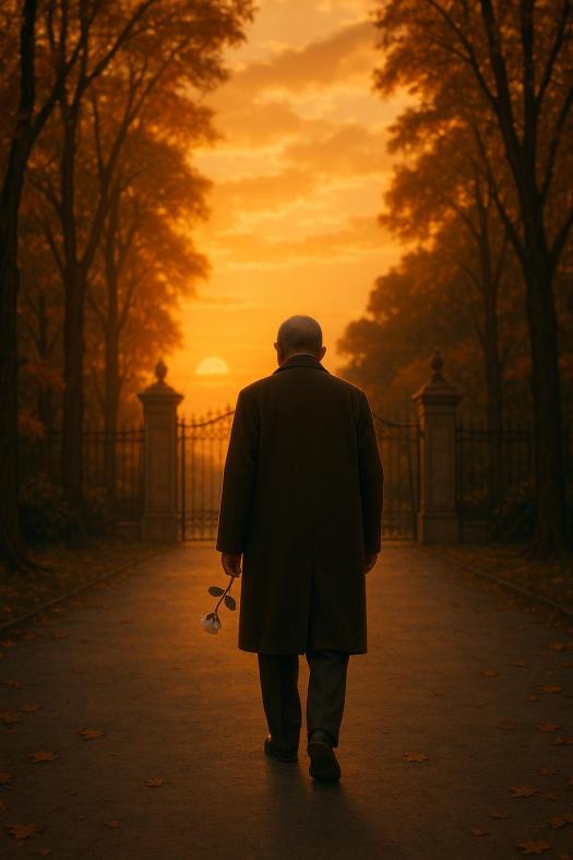
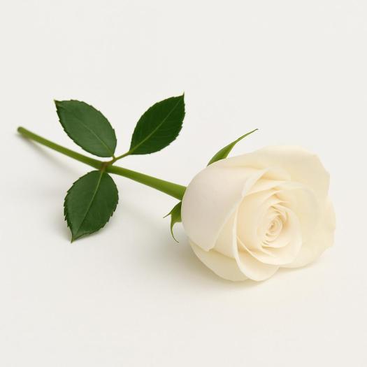
A Single Rose
It bloomed late.
A rose — small, ivory white, almost shy — on the far edge of the western bed, where the soil had always been stingy and the sun reluctant. I hadn’t planted it. Not directly. Perhaps it was a graft from an older root, or a survivor of some careless gardener’s forgotten trial.
But there it was. Unexpected. Unasked for.
And quietly perfect.
That morning, I knelt beside it with the care one might offer a relic or a final confession. I touched a petal — soft as breath — and let my fingers linger. It trembled slightly under the weight of the breeze, or perhaps time.
I didn’t call anyone over. I didn’t record it in the garden log. I simply watched.
Around me, the city moved — bicycles on gravel paths, distant loudspeakers reciting slogans, the slow sweep of a broom on concrete. Beijing in its new skin.
Inside me, there was no longing.
Not for palaces. Not for ceremony. Not even for forgiveness.
I thought of the men who had bowed to me. The women I had married but never truly known. The courtiers, the generals, the Party instructors, the guards. Even the Soviet interpreter who once told me I spoke Mandarin like someone reading an opera libretto.
And then I thought of Mr. Shen. Of the compost woman. Of the boy who crushed the chrysanthemums. Of the girl who read poetry. Of the rose, quietly defiant in the stubborn soil.
And I smiled.
When I stood to leave, I plucked the rose — not for display, not for ceremony — but as a gesture to the life that grows when no one is watching.
At home, I placed it in a small jar. No water. No vase. Just a cracked ceramic cup once used to rinse brushes in the palace school. The rose stood perfectly still on the table as I made tea.
That night, I dreamt I was planting trees. Not alone. Not for an empire. Just planting.
And no one called me emperor.
And no one needed to.
Epilogue
When I died, there was no parade. No black horses, no imperial wailing. Just a modest cremation and a government-issued notice of passing:
“Citizen Pu Yi, aged 61.”
But the garden still stands.
And every few years, a single white rose appears on the western edge of the bed.
No one knows who planted it.
But it blooms just the same.
A Single Rose in Tianjin
No throne remains, no court, no crown,
Just whispers in a northern town.
Where once he ruled, now silence grows—
His legacy: a single rose.
In Tianjin’s heart, on Anshan Road,
A garden where his story slowed.
Jingyuan, the Garden of Serenity,
Holds echoes of his identity.
From emperor to gardener’s grace,
He found his peace in this quiet place.
No longer bound by royal decree,
He tended plants with humility.
Visitors come, the curious kind,
Seeking traces he left behind.
But find instead a tranquil scene,
Where history and nature convene.
No monuments of marble stand,
Just blooming flowers by his hand.
A testament to life’s repose—
His legacy: a single rose.
Visiting Jingyuan (Garden of Serenity):
- Location: No. 70 Anshan Road, Heping District, Tianjin, China.
- Getting There: Accessible via Tianjin Metro Line 1, Anshan Road Station, or by buses No. 3, 50, 673, 632, and 800.
- Opening Hours: Tuesday to Sunday, 8:30 AM – 12:00 PM and 1:30 PM – 4:30 PM. Closed on Mondays.
- Admission: Approximately 20 Yuan.
Jingyuan, once Puyi’s residence, now serves as a museum preserving the memory of China’s last emperor and the serenity he found in his final years.